Battle of Hastings
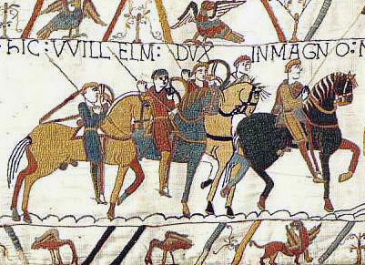
This is Hastings, on the southeastern coast of England — perched on a low ridge just inland from the English Channel, the narrow strip of water separating the island of Great Britain from continental Europe. On 14 October 1066, the Norman duke William the Conqueror defeated the Anglo-Saxon King Harold II here, killing Harold and ending Anglo-Saxon rule over England.
England sits on the northwestern edge of Europe, separated from France by the Channel at its narrowest point — the Strait of Dover — just 33 kilometres wide, making this coast one of history's most invaded and contested shorelines. That geographic closeness to France shaped everything that followed: Norman French culture, language, and feudal law poured across that narrow gap, permanently transforming English society.
This event appears in EraPin — a daily game where you decode geographic clues to place historical events on the map. Five rounds. Free to play.
Play today's EraPin →For teachers
This event in EraPin gives students practice in absolute and relative location reasoning — a core skill in the C3 Framework and most geography standards.
The clue uses spatial language students must decode:
Combined with the era markers (Swords, shields, chainmail, longships, mead halls, monasteries), students reason their way to Hastings, United Kingdom in 1066 without prior knowledge of the specific event. Each clue is designed to teach geographic literacy, not just test it.
See how EraPin works in classrooms →Related events
Source: EraPin event archive. Historical details drawn from publicly available sources including Wikipedia.