1912
Balkan Wars (1912–1913)
ADRIANOPLE (EDIRNE) · OTTOMAN EMPIRE (MODERN TURKEY)

Between 1912 and 1913, the Balkan nations of Bulgaria, Serbia, Greece, and Montenegro fought two back-to-back wars that dramatically redrew the map of southeastern Europe. In the First Balkan War (1912–13), they attacked the declining Ottoman Empire and rapidly seized almost all…
Read the full account
Between 1912 and 1913, the Balkan nations of Bulgaria, Serbia, Greece, and Montenegro fought two back-to-back wars that dramatically redrew the map of southeastern Europe. In the First Balkan War (1912–13), they attacked the declining Ottoman Empire and rapidly seized almost all its remaining European territory, including the fortress city of Adrianople (modern Edirne, Turkey). A Second Balkan War (1913) broke out immediately as the victors fought each other over the spoils. The wars displaced hundreds of thousands of people and intensified nationalist hatreds — particularly between Serbia and Austria-Hungary — directly creating the conditions that led to the assassination of Archduke Franz Ferdinand in Sarajevo in 1914 and the outbreak of World War I.
1914
First Battle of Ypres
YPRES · BELGIUM

This is Ypres, a city in West Flanders, Belgium — sitting on the flat coastal plain of northwestern Europe, just inland from the English Channel that separates it from Britain. During the First World War, the First Battle of Ypres was fought here in 1914, as Allied and German…
Read the full account
This is Ypres, a city in West Flanders, Belgium — sitting on the flat coastal plain of northwestern Europe, just inland from the English Channel that separates it from Britain. During the First World War, the First Battle of Ypres was fought here in 1914, as Allied and German forces clashed along the Western Front in a brutal struggle for control of this strategically vital town. Belgium occupies one of Europe's most fought-over corridors — a narrow, flat country wedged between France, Germany, Luxembourg, and the Netherlands, with no natural mountain barriers to slow advancing armies. That geographic openness made Belgium a repeated invasion route throughout history, earning it the grim nickname 'the battlefield of Europe.'
1914
Christmas Truce of 1914
YPRES · BELGIUM

This moment unfolded near Ypres, in Belgium — a small, low-lying country squeezed between France to the south and west, Germany to the east, and the North Sea to the north, exactly the kind of flat, open terrain that made it a brutal battleground. On Christmas Eve and Christmas…
Read the full account
This moment unfolded near Ypres, in Belgium — a small, low-lying country squeezed between France to the south and west, Germany to the east, and the North Sea to the north, exactly the kind of flat, open terrain that made it a brutal battleground. On Christmas Eve and Christmas Day 1914, German and Allied soldiers along sections of the Western Front spontaneously stopped shooting, crossed into no man's land, exchanged greetings, and in some places played football together — one of the most extraordinary informal truces in military history. Belgium sits at a geographic crossroads where the North European Plain funnels movement between the great powers of France and Germany, which is precisely why its soil has soaked up so many of Europe's wars across the centuries. Smaller than the state of Maryland but bordered by three major powers, Belgium's flat, open landscape offers almost no natural defensive barriers — rivers and ridgelines are shallow and short, leaving armies to fight over every muddy field.
1914
Battle of Tannenberg
TANNENBERG · GERMANY
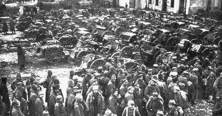
This was Tannenberg, a village in what is now northeastern Poland — set on the low, lake-scattered plains that stretch between the Baltic coast to the north and the Masurian Lake District to the south. From August 26–30, 1914, German forces under Hindenburg and Ludendorff…
Read the full account
This was Tannenberg, a village in what is now northeastern Poland — set on the low, lake-scattered plains that stretch between the Baltic coast to the north and the Masurian Lake District to the south. From August 26–30, 1914, German forces under Hindenburg and Ludendorff encircled and virtually destroyed the Russian Second Army on the Eastern Front, capturing nearly 92,000 prisoners in one of history's most complete battlefield encirclements. The region sits on the North European Plain, a vast, flat corridor that runs from France all the way to Russia with almost no natural barriers — which is exactly why armies have swept back and forth across it for centuries. This geographic openness made northeastern Europe a natural invasion route and a recurring battleground in both World Wars.
1914
Assassination of Archduke Franz Ferdinand
SARAJEVO · BOSNIA AND HERZEGOVINA
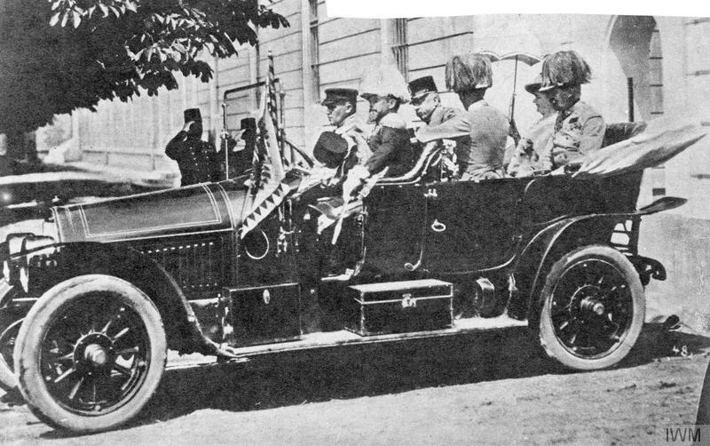
This is Sarajevo, the capital of modern Bosnia and Herzegovina — a city nestled in a mountain-ringed valley along the Miljacka River, deep in the Balkan Peninsula where Central Europe grades into the southeastern corner of the continent. On June 28, 1914, Archduke Franz…
Read the full account
This is Sarajevo, the capital of modern Bosnia and Herzegovina — a city nestled in a mountain-ringed valley along the Miljacka River, deep in the Balkan Peninsula where Central Europe grades into the southeastern corner of the continent. On June 28, 1914, Archduke Franz Ferdinand, heir to the Austro-Hungarian throne, was shot and killed by Gavrilo Princip, a Bosnian-Serb nationalist tied to the Black Hand secret society — a single act that triggered the July Crisis and pulled every major European power into war within six weeks. The Balkans sit at the crossroads where the European continent narrows toward the Aegean and Black Seas, a region where Slavic, Ottoman, and Habsburg empires overlapped for centuries, making it one of history's most contested cultural and political fault lines. That geographic pressure-cooker quality — mountains carving up territory, rival powers pressing in from every direction — helps explain why this compact peninsula produced so many flashpoints in the modern era.
1914
First Battle of the Marne
MEAUX · FRANCE
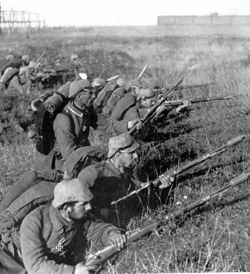
This is Meaux, France, a market town on the Marne River about 40 kilometers east of Paris — exactly the river crossing and rolling farmland the clue described. In September 1914, French and British forces halted a massive German advance here in the First Battle of the Marne, a…
Read the full account
This is Meaux, France, a market town on the Marne River about 40 kilometers east of Paris — exactly the river crossing and rolling farmland the clue described. In September 1914, French and British forces halted a massive German advance here in the First Battle of the Marne, a turning point that stopped enemy troops from reaching Paris and forced a retreat to defensive trenches. The Marne River is a major tributary of the Seine, draining a wide basin of northeastern France before flowing west through Paris and out to the English Channel. This river network made the region both a natural invasion corridor from the east and a defensive lifeline for the French capital — geography that shaped European warfare for centuries.
1915
Gallipoli campaign
CONSTANTINOPLE · OTTOMAN EMPIRE
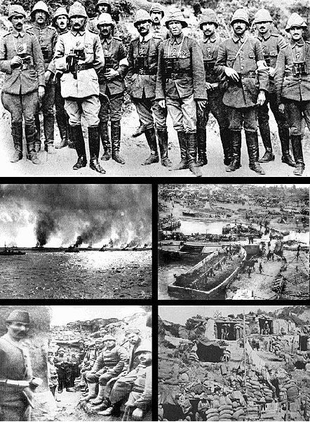
This was the Gallipoli Peninsula in Turkey, jutting into the Aegean Sea at the point where the Dardanelles strait — the narrow waterway dividing Europe from Asia — connects to the Sea of Marmara. In 1915, Allied forces launched a major amphibious assault here during the First…
Read the full account
This was the Gallipoli Peninsula in Turkey, jutting into the Aegean Sea at the point where the Dardanelles strait — the narrow waterway dividing Europe from Asia — connects to the Sea of Marmara. In 1915, Allied forces launched a major amphibious assault here during the First World War, attempting to seize the strait and open a route to the Ottoman capital; the campaign lasted months, cost hundreds of thousands of casualties on both sides, and ultimately failed. The Dardanelles is one of the world's most strategically important waterways — only about 1.2 kilometres wide at its narrowest — because it controls the only sea passage between the Black Sea and the Mediterranean, making whoever holds it enormously powerful over trade and naval movement. Turkey sits at the crossroads of two continents, and the Gallipoli Peninsula is one of the most vivid places on Earth where that Europe-Asia divide becomes a physical, visible line of water.
1916
Arab Revolt
MECCA · OTTOMAN EMPIRE (PRESENT-DAY SAUDI ARABIA)

This is Mecca, in present-day Saudi Arabia — a city nestled in the narrow Hejaz coastal corridor where the Red Sea's eastern shore meets the rugged Hejaz mountain range on the western edge of the Arabian Peninsula. In June 1916, Sharif Hussein bin Ali launched an Arab uprising…
Read the full account
This is Mecca, in present-day Saudi Arabia — a city nestled in the narrow Hejaz coastal corridor where the Red Sea's eastern shore meets the rugged Hejaz mountain range on the western edge of the Arabian Peninsula. In June 1916, Sharif Hussein bin Ali launched an Arab uprising against Ottoman rule from this city, supported by British advisors including T. E. Lawrence, in a revolt that reshaped the Middle East and raised Arab hopes of independence that were largely unfulfilled after the war. The Hejaz region runs along the Red Sea like a spine, separating the coastal lowlands from the vast interior of the Arabian Peninsula — a geography that made it both a crossroads for trade and pilgrimage and a strategically vital corridor for controlling the region. Mecca sits at the heart of this corridor and is the holiest city in Islam, drawing millions of pilgrims each year from across the Muslim world.
1916
Battle of Jutland
NORTH SEA (OFF JUTLAND) · DENMARK

This naval battle took place in the North Sea off the Jutland Peninsula, the finger of land that extends northward from continental Europe toward Norway and Sweden, separating the North Sea from the Baltic. Fought over two days in 1916, the Battle of Jutland was the largest…
Read the full account
This naval battle took place in the North Sea off the Jutland Peninsula, the finger of land that extends northward from continental Europe toward Norway and Sweden, separating the North Sea from the Baltic. Fought over two days in 1916, the Battle of Jutland was the largest naval engagement of World War I, pitting the British Royal Navy's Grand Fleet against the German Imperial Navy's High Seas Fleet; Germany sank more ships and killed more sailors, yet the German fleet retreated and never seriously challenged British naval dominance again. The North Sea is a relatively shallow body of water — rarely deeper than 200 metres — sitting on the continental shelf between Britain and northwestern Europe, making it one of the world's most strategically contested stretches of ocean for centuries. Controlling it meant controlling access between the Atlantic and the Baltic, which is exactly why both sides fought so hard here.
1916
Battle of the Somme
ALBERT · FRANCE

The battle unfolded around Albert, France, on the flat farmland of the upper Somme valley, roughly halfway between Paris and the narrow Strait of Dover facing England. Beginning 1 July 1916, British and French forces pushed against German lines for nearly five months, with over…
Read the full account
The battle unfolded around Albert, France, on the flat farmland of the upper Somme valley, roughly halfway between Paris and the narrow Strait of Dover facing England. Beginning 1 July 1916, British and French forces pushed against German lines for nearly five months, with over three million men engaged and more than one million killed or wounded, making it one of history's deadliest battles for barely any territorial gain. This part of northern France sits on a chalky, gently rolling plain carved by slow rivers like the Somme, terrain with almost no natural cover — which is why armies dug hundreds of miles of trenches here instead of maneuvering, turning open farmland into a fixed, grinding front line. That same flat corridor between Paris and the Channel coast has been a marching route for invading armies for centuries, making northern France one of Europe's most fought-over landscapes.
1916
Battle of Verdun
VERDUN · FRANCE

This was Verdun, a fortified city on the Meuse River in northeastern France — sitting in the rolling hills of the Western European interior, roughly midway between the Rhine to the east and the English Channel coast to the northwest. In 1916, two industrial armies fought here…
Read the full account
This was Verdun, a fortified city on the Meuse River in northeastern France — sitting in the rolling hills of the Western European interior, roughly midway between the Rhine to the east and the English Channel coast to the northwest. In 1916, two industrial armies fought here for nearly ten months in one of World War I's longest and deadliest battles, with around 700,000 soldiers killed or wounded on both sides, as artillery, poison gas, and machine guns turned the landscape into a wasteland of craters and mud. Verdun sits in the Lorraine region, a historically contested borderland between France and Germany — the kind of flat, river-crossed terrain that armies have fought over for centuries because it offers no natural wall to stop an advance. That lack of a strong geographic barrier between France and its eastern neighbours made this corridor one of the most fought-over strips of land in all of European history.
1916
Sykes-Picot Agreement
LONDON · UNITED KINGDOM

London, the capital of the United Kingdom, sits on the River Thames in southeast England — on the northwest edge of Europe, separated from France by the narrow English Channel. There, in May 1916, a British diplomat and a French diplomat secretly agreed to carve up the Arab…
Read the full account
London, the capital of the United Kingdom, sits on the River Thames in southeast England — on the northwest edge of Europe, separated from France by the narrow English Channel. There, in May 1916, a British diplomat and a French diplomat secretly agreed to carve up the Arab territories of the collapsing Ottoman Empire into separate spheres of influence for their two countries. The agreement drew borders across the lands between the Mediterranean Sea, the Arabian Peninsula, and the Persian Gulf — a vast region stretching from modern Syria and Lebanon to Iraq and beyond. Britain sits on an island formed when rising seas after the last Ice Age flooded the land bridge connecting it to continental Europe, making the Thames estuary and the Channel two of history's most strategically watched waterways.
1917
Zimmermann Telegram
WASHINGTON, D.C. · UNITED STATES

Washington, D.C., the capital of the United States, sits on the Atlantic seaboard of North America, roughly midway along the eastern coast between the Canadian border and the Gulf of Mexico — the destination where this intercepted message caused an uproar. In January 1917…
Read the full account
Washington, D.C., the capital of the United States, sits on the Atlantic seaboard of North America, roughly midway along the eastern coast between the Canadian border and the Gulf of Mexico — the destination where this intercepted message caused an uproar. In January 1917, German Foreign Secretary Arthur Zimmermann sent a secret telegram to Mexico proposing a military alliance against the United States; British intelligence intercepted it, and when its contents were made public, the resulting outrage helped push the U.S. Congress to declare war on Germany. Washington, D.C. occupies a low, flat position on the Potomac River, chosen deliberately on the border between northern and southern states as a political compromise when the young nation needed a neutral federal capital. The Atlantic coast here connects via ocean routes to both Europe and the Caribbean, making it a natural hub for the transatlantic communications and diplomacy that defined this era of world war.
1917
United States Enters World War I
WASHINGTON, D.C. · UNITED STATES

Washington, D.C., the capital of the United States, sits on the Potomac River along the eastern seaboard of North America, roughly midway up the Atlantic coast between the Gulf of Mexico and the Canadian border — the ocean the player was looking across toward Europe. On April 6…
Read the full account
Washington, D.C., the capital of the United States, sits on the Potomac River along the eastern seaboard of North America, roughly midway up the Atlantic coast between the Gulf of Mexico and the Canadian border — the ocean the player was looking across toward Europe. On April 6, 1917, the U.S. Congress declared war on Germany, formally entering World War I on the side of the Allies, driven by Germany's unrestricted submarine warfare targeting Atlantic shipping lanes and a secret telegram proposing a military alliance against the United States. Washington, D.C. is a federal district carved out of land between Maryland and Virginia, deliberately placed on the Potomac to sit between the northern and southern states at the country's founding. The Atlantic Ocean, which separates North America from Europe by roughly 6,000 kilometres, was the critical geographic stage for the submarine campaign that pulled the United States into the conflict.
1917
Bolshevik Seizure of Power (October Revolution)
PETROGRAD · RUSSIA

This is Petrograd — now called Saint Petersburg — in Russia, sitting at the eastern tip of the Baltic Sea where the Neva River meets the Gulf of Finland, exactly where Europe's great northern plain transitions into the Eurasian heartland. In October 1917, Lenin's Bolshevik Party…
Read the full account
This is Petrograd — now called Saint Petersburg — in Russia, sitting at the eastern tip of the Baltic Sea where the Neva River meets the Gulf of Finland, exactly where Europe's great northern plain transitions into the Eurasian heartland. In October 1917, Lenin's Bolshevik Party overthrew Russia's Provisional Government, seizing control of the city and establishing the foundation of a Soviet state — one of the most consequential political upheavals of the modern era. Saint Petersburg sits at roughly 60 degrees north latitude, on the same latitude as southern Alaska, making it one of the world's largest cities in such a cold, high-latitude position. The city was built by Peter the Great on marshy delta islands where the Neva meets the Baltic, giving Russia its long-sought warm-water access to European sea trade — a geographic ambition that shaped Russian expansion for centuries.
1917
Balfour Declaration
LONDON · UNITED KINGDOM

The event took place in London, the capital of the United Kingdom, situated on the River Thames in southeastern England — on the large island off northwestern Europe's Atlantic coast, separated from France by the English Channel. In 1917, British Foreign Secretary Arthur Balfour…
Read the full account
The event took place in London, the capital of the United Kingdom, situated on the River Thames in southeastern England — on the large island off northwestern Europe's Atlantic coast, separated from France by the English Channel. In 1917, British Foreign Secretary Arthur Balfour issued a formal letter expressing British government support for establishing a national home for the Jewish people in Palestine, while insisting that the rights of existing non-Jewish communities there must not be harmed. The declaration became one of the most consequential diplomatic documents of the modern era, shaping the future of the eastern Mediterranean region. Britain sits on the largest of the British Isles, a cluster of islands between the Atlantic Ocean and the North Sea, whose position made it a dominant naval and colonial power projecting influence across the globe for centuries.
1918
Influenza Pandemic of 1918
CAMP FUNSTON, KANSAS · UNITED STATES

Camp Funston sits in Kansas, deep in the interior of the United States — on the broad, flat Great Plains that stretch from the Gulf of Mexico northward toward Canada, far from any ocean coast. It was here, in 1918, that one of the earliest known outbreaks of the influenza…
Read the full account
Camp Funston sits in Kansas, deep in the interior of the United States — on the broad, flat Great Plains that stretch from the Gulf of Mexico northward toward Canada, far from any ocean coast. It was here, in 1918, that one of the earliest known outbreaks of the influenza pandemic later called the 'Spanish Flu' was recorded; the disease ultimately infected an estimated 500 million people worldwide and killed between 50 and 100 million, more than the entire First World War. Kansas lies near the geographic center of North America, sitting on the vast interior lowland basin between the Rocky Mountains to the west and the Appalachians to the east. This central position, connected to military movement networks spreading in every direction, made it a chilling starting point for a disease that would circle the entire globe.
1918
Armistice Day and End of World War I on the Western Front
COMPIÈGNE · FRANCE

The location is the Forest of Compiègne, about 80 kilometres northeast of Paris in northern France — sitting in the broad, low basin drained by the Oise River, a tributary of the Seine, well inland from the English Channel. On November 11, 1918, representatives of the Allied…
Read the full account
The location is the Forest of Compiègne, about 80 kilometres northeast of Paris in northern France — sitting in the broad, low basin drained by the Oise River, a tributary of the Seine, well inland from the English Channel. On November 11, 1918, representatives of the Allied powers and Germany signed an armistice inside a railway carriage parked in that forest, ending the major fighting on the Western Front and concluding World War I's bloodiest theatre of war. Northern France sits on a wide sedimentary plain that stretches from the Channel coast deep into the continent, broken by no serious mountain barriers — which is precisely why this region has been one of Europe's most fought-over corridors for centuries, offering flat, open routes between the Atlantic coast and Central Europe. The Oise and Seine river valleys cutting through this plain have long served as natural highways into the French interior, making the land around Compiègne both strategically vital and historically scarred.
1918
Treaty of Brest-Litovsk
BREST-LITOVSK · RUSSIAN EMPIRE

The signing took place in Brest-Litovsk, a city now called Brest in modern Belarus, sitting on the flat lowland plain where the Bug River marks the boundary between Eastern and Central Europe, roughly midway between the Baltic and Black Seas. On March 3, 1918, Soviet Russia…
Read the full account
The signing took place in Brest-Litovsk, a city now called Brest in modern Belarus, sitting on the flat lowland plain where the Bug River marks the boundary between Eastern and Central Europe, roughly midway between the Baltic and Black Seas. On March 3, 1918, Soviet Russia signed a treaty with the Central Powers here, ending its involvement in World War I at enormous cost — surrendering vast territories including Ukraine, Finland, and the Baltic states, stripping away roughly a third of European Russia's population and farmland. Brest sits at a geographic crossroads that has made it strategically fought over for centuries: it lies on the natural invasion corridor across the North European Plain, the same flat, open lowland highway that armies have used to march between Western Europe and Russia for hundreds of years. That absence of mountain barriers across this plain is one of the defining geographic facts of European military history.
1918
Wilson's Fourteen Points Address
WASHINGTON, D.C. · UNITED STATES

Washington, D.C., the capital of the United States, sits on the Potomac River along the Atlantic coastal plain, east of the Appalachian Mountains — exactly the eastern seaboard setting the clue described. On January 8, 1918, President Woodrow Wilson delivered his Fourteen Points…
Read the full account
Washington, D.C., the capital of the United States, sits on the Potomac River along the Atlantic coastal plain, east of the Appalachian Mountains — exactly the eastern seaboard setting the clue described. On January 8, 1918, President Woodrow Wilson delivered his Fourteen Points speech to Congress there, laying out a vision for a post-World War One world built on national self-determination, open diplomacy, free trade, and a new international body called the League of Nations. The speech shaped the Paris Peace Conference negotiations that followed the war. Washington, D.C. was purpose-built as a federal capital, carved from land between Maryland and Virginia on the Potomac, placing the seat of government at the geographic midpoint of the original thirteen states along the Atlantic coast.
1918
Operation Michael
SAINT-QUENTIN · FRANCE

This offensive launched from near Saint-Quentin, a town in northern France — sitting on the flat plains of Picardy, roughly midway between the English Channel coast and the Belgian border, west of the Rhine and east of Paris. In spring 1918, German forces launched Operation…
Read the full account
This offensive launched from near Saint-Quentin, a town in northern France — sitting on the flat plains of Picardy, roughly midway between the English Channel coast and the Belgian border, west of the Rhine and east of Paris. In spring 1918, German forces launched Operation Michael, a massive assault from their established Hindenburg Line positions, driving westward in an attempt to shatter the Allied front before American reinforcements could tip the balance. The Picardy plain offered little natural cover — no mountains, no wide rivers to anchor a defence — which is partly why this stretch of northern France became one of the most fought-over corridors in the entire war. The region sits on a broad, gently rolling chalk plateau that connects the Paris Basin to the Belgian lowlands, making it a natural invasion corridor that armies have used for centuries.
1918
Armistice of 11 November 1918
COMPIÈGNE · FRANCE

On 11 November 1918, representatives of the Entente powers and Germany signed an armistice in a railroad car parked in the Compiègne Forest, near the town of Compiègne, France, bringing the fighting of World War I to an end on land, at sea, and in the air. It was the last of…
Read the full account
On 11 November 1918, representatives of the Entente powers and Germany signed an armistice in a railroad car parked in the Compiègne Forest, near the town of Compiègne, France, bringing the fighting of World War I to an end on land, at sea, and in the air. It was the last of four armistices that concluded the war: Bulgaria, the Ottoman Empire, and Austria-Hungary had already agreed to terms. Germany's government had approached American president Woodrow Wilson to negotiate on the basis of a recent speech and his earlier "Fourteen Points," which subsequently became the foundation for the German surrender terms at the Paris Peace Conference held the following year.
1919
Paris Peace Conference (1919–1920)
PARIS · FRANCE

Paris, France — sitting on a wide bend of the Seine River in the heart of Western Europe, exactly where the flat North European Plain rolls toward the Atlantic coast — was where Allied leaders convened in 1919 to reshape the world after World War I. Representatives of four major…
Read the full account
Paris, France — sitting on a wide bend of the Seine River in the heart of Western Europe, exactly where the flat North European Plain rolls toward the Atlantic coast — was where Allied leaders convened in 1919 to reshape the world after World War I. Representatives of four major Allied powers held the Paris Peace Conference, producing a series of treaties that redrew national borders across Europe, the Middle East, and beyond, dismantling defeated empires and creating new states. Paris sits at the geographic core of Western Europe, roughly equidistant between the English Channel to the north and the Mediterranean coast to the south, which has made it a natural hub for continental diplomacy for centuries. The Seine, flowing northwest through the city before emptying into the English Channel near Normandy, connected Paris to Atlantic trade routes and helped it grow into one of Europe's great political and cultural capitals.
1919
U.S. Senate Rejection of the Treaty of Versailles
WASHINGTON, D.C. · UNITED STATES
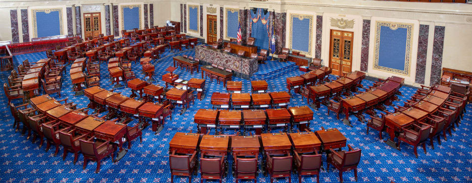
Washington, D.C., the capital of the United States, sits on the eastern seaboard of North America, wedged between the Atlantic coastal plain and the Appalachian Mountains, roughly midway up the continent's eastern edge. In November 1919 and again in March 1920, the U.S. Senate…
Read the full account
Washington, D.C., the capital of the United States, sits on the eastern seaboard of North America, wedged between the Atlantic coastal plain and the Appalachian Mountains, roughly midway up the continent's eastern edge. In November 1919 and again in March 1920, the U.S. Senate voted twice against ratifying the Treaty of Versailles, blocking American membership in the League of Nations and signaling a turn back toward isolationism rather than deep international entanglement. Washington, D.C. is unusual geographically because it is not part of any U.S. state — it occupies a small federal district on the Potomac River, carved from land between Maryland and Virginia. The Potomac flows southeast into Chesapeake Bay, one of the largest estuaries on the Atlantic coast, making the capital city both a river city and a coastal-plain city at once.
1919
Signing of the Treaty of Versailles
VERSAILLES · FRANCE

On 28 June 1919 — exactly five years after the assassination of Archduke Franz Ferdinand — Germany and the Allied powers signed the Treaty of Versailles in the Hall of Mirrors at the Palace of Versailles, France. Germany was forced to accept sole responsibility for the war, pay…
Read the full account
On 28 June 1919 — exactly five years after the assassination of Archduke Franz Ferdinand — Germany and the Allied powers signed the Treaty of Versailles in the Hall of Mirrors at the Palace of Versailles, France. Germany was forced to accept sole responsibility for the war, pay enormous reparations, surrender territory to neighbouring countries, and reduce its army to just 100,000 men. Germany lost about 13% of its territory and 10% of its population. The humiliation and economic hardship caused by the treaty created widespread resentment that Adolf Hitler later exploited, contributing directly to the rise of Nazism and the outbreak of World War II just twenty years later.
1920
Formation of the League of Nations
GENEVA · SWITZERLAND

This was Geneva, Switzerland — a city nestled at the southwestern corner of Lake Geneva, where the Alps rise to the south and the Jura range curves to the west, placing it at a crossroads of western European geography. In January 1920, Geneva became the headquarters of the…
Read the full account
This was Geneva, Switzerland — a city nestled at the southwestern corner of Lake Geneva, where the Alps rise to the south and the Jura range curves to the west, placing it at a crossroads of western European geography. In January 1920, Geneva became the headquarters of the world's first major international peacekeeping organization, born from a set of principles proposed by U.S. President Woodrow Wilson after the First World War — though the United States Senate ultimately refused to join. Switzerland's position at the meeting point of French, German, and Italian cultural zones, combined with its long tradition of political neutrality, made Geneva a natural home for international diplomacy. That neutrality is geographic as much as political: Switzerland is a landlocked mountain nation surrounded by larger powers, which historically made it a buffer zone and a meeting ground rather than a battlefield.